Australia GIS data sources
- Region
- Australia and New Zealand
- ISO 3166
- AU · AUS
- Sources
- 36
- Themes
- 16
- Last verified
Where to download GIS data for Australia: 36 sources across 16 themes, led by Geoscience Australia and Bureau of Meteorology. 15 offer vector downloads such as Shapefile, GeoPackage or GeoJSON, 7 cover elevation including LiDAR. 27 are under an open licence. Every link was last checked on 18 Oct 2026.
- Australia in the LiDAR & elevation atlas Partial open LiDAR
- Australia in the aerial & satellite imagery atlas Partial open imagery
National and OpenStreetMap sources for Australia
Boundaries & admin 2
Administrative boundary data for every country-
ABS digital boundary files (ASGS Ed. 3) (opens in a new tab)
Download Cost: FreeAustralian Bureau of Statistics
- Boundaries & admin
- Census & statistics
Verified
-
geoBoundaries administrative boundaries (opens in a new tab)
API Cost: FreeWilliam & Mary geoLab
JSON API listing every available admin level with direct download links.
- Boundaries & admin
Verified
Elevation / DEM 1
Free DEM, LiDAR and elevation data for every country-
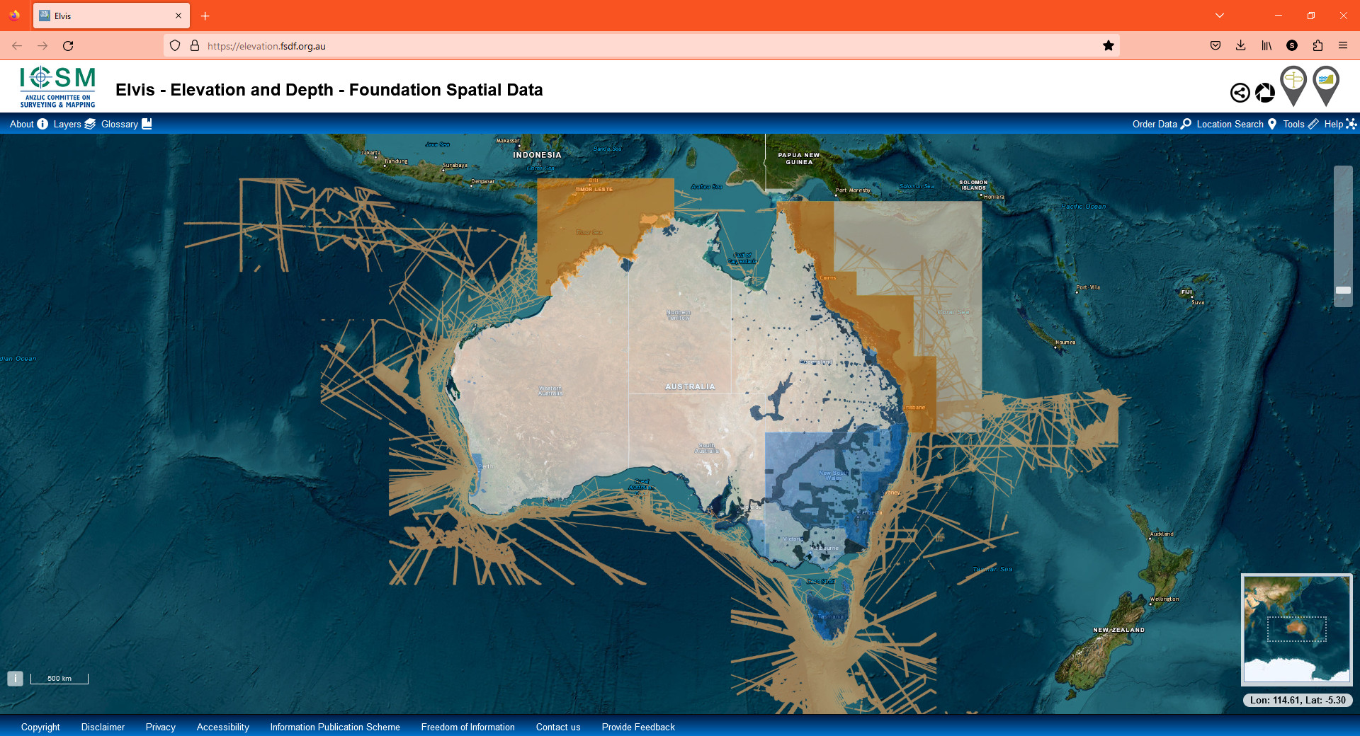
Elvis – Elevation and Depth (opens in a new tab)
Download Cost: FreeICSM / Geoscience Australia
Commonwealth, state and territory elevation and bathymetry data in one place.
- Elevation / DEM
- Hydrology
Verified
-
Geoscience Australia
Analysis-ready Landsat and Sentinel-2 archives and derived products (water, land cover, coastlines) via Open Data Cube and AWS.
- Imagery
- Land cover
- Hydrology
Verified
Land cover 2
Land cover datasets for every country-
DEA Land Cover (opens in a new tab)
Download Cost: FreeGeoscience Australia
Annual 30 m land cover from 1988 onwards using the FAO LCCS taxonomy.
- Land cover
Verified
-
National Vegetation Information System (NVIS) (opens in a new tab)
Download Cost: FreeDepartment of Climate Change, Energy, the Environment and Water
Major vegetation groups and subgroups, present and pre-1750, at 100 m.
- Land cover
- Environment
Verified
Census & statistics 2
Census and statistics data for every country-
AURIN (opens in a new tab)
Portal Cost: FreeAustralian Urban Research Infrastructure Network
- Census & statistics
- Transport
Verified
-
Census DataPacks (ABS) (opens in a new tab)
Download Cost: FreeAustralian Bureau of Statistics
2021 Census tables for every ASGS geography, ready to join to the digital boundary files.
- Census & statistics
- Population
Verified
Addresses & cadastre 8
Address and cadastral data for every country-
G-NAF (Geocoded National Address File) (opens in a new tab)
Download Cost: FreeGeoscape Australia
- Addresses & cadastre
Verified
-
NSW Spatial Collaboration Portal (opens in a new tab)
Portal Cost: FreeNSW Spatial Services · New South Wales
NSW foundation spatial data (cadastre, imagery, addresses, topography) as services and downloads.
- Addresses & cadastre
- Imagery
- Boundaries & admin
- Transport
Verified
-
Vicmap catalogue (opens in a new tab)
Download Cost: FreeDepartment of Transport and Planning (Victoria) · Victoria
Victoria’s foundation datasets (property, address, transport, elevation, hydro), ordered free via DataShare.
- Addresses & cadastre
- Transport
- Elevation / DEM
- Hydrology
- Boundaries & admin
Not verified (site blocks automated checks) · 18 Oct 2026 (no response)
-
QSpatial (opens in a new tab)
Download Cost: FreeQueensland Government · Queensland
Queensland’s spatial catalogue with free downloads including the digital cadastral database.
- Addresses & cadastre
- Boundaries & admin
- Environment
- Elevation / DEM
Verified
-
DataWA / SLIP (opens in a new tab)
Portal Cost: Free with registrationLandgate (Western Australia) · Western Australia
Western Australian government spatial data; some datasets require a free SLIP account.
- Addresses & cadastre
- Environment
- Boundaries & admin
Verified
-
Data.SA (opens in a new tab)
Portal Cost: FreeGovernment of South Australia · South Australia
South Australian open data including cadastre, suburbs, roads and environmental layers.
- Addresses & cadastre
- Boundaries & admin
- Environment
- Transport
Verified
-
theLIST (opens in a new tab)
Web viewer Cost: MixedLand Tasmania · Tasmania
Tasmania’s Land Information System; open data downloads via the LISTdata portal.
- Addresses & cadastre
- Imagery
- Elevation / DEM
- Boundaries & admin
Verified
-
ACTmapi (opens in a new tab)
Web viewer Cost: FreeACT Government · Australian Capital Territory
ACT spatial viewer; underlying data is published on the ACT open data portal.
- Addresses & cadastre
- Imagery
- Environment
Not verified (site blocks automated checks) · 18 Oct 2026 (no response)
Transport 1
Road, rail and transport data for every country-
OpenStreetMap extract – Australia (opens in a new tab)
Download Cost: FreeGeofabrik / OpenStreetMap contributors
Daily OSM extract.
- Transport
- Boundaries & admin
- Hydrology
Verified
Hydrology 2
River, lake and hydrology data for every country-
DEA Water Observations (opens in a new tab)
Download Cost: FreeGeoscience Australia
Surface water detected in every Landsat scene since 1986; useful for flood history.
- Hydrology
- Natural hazards
Verified
-
Australian Hydrological Geospatial Fabric (Geofabric) (opens in a new tab)
Download Cost: FreeBureau of Meteorology
National stream network, catchments and groundwater features derived from the 9-second DEM.
- Hydrology
Verified
Climate & weather 2
Climate and weather data for every country-
Climate Data Online (opens in a new tab)
Download Cost: FreeBureau of Meteorology
Daily and monthly rainfall and temperature for thousands of stations.
- Climate & weather
Verified
-
Australian gridded climate data (AGCD) (opens in a new tab)
Download Cost: FreeBureau of Meteorology
5 km gridded rainfall and temperature maps; grids downloadable from each map page.
- Climate & weather
Verified
Natural hazards 2
Natural hazard data for every country-
Australian Flood Risk Information Portal (opens in a new tab)
Web viewer Cost: FreeGeoscience Australia
Catalogue of local flood studies and flood extent mapping from councils and states.
- Natural hazards
- Hydrology
Verified
-
DEA Hotspots (opens in a new tab)
Download Cost: FreeGeoscience Australia
Near-real-time satellite bushfire hotspot detections with WFS/GeoJSON access.
- Natural hazards
Verified
Geology 3
Geology data for every country-
Geoscience Australia data catalogue (opens in a new tab)
Portal Cost: FreeGeoscience Australia
- Geology
- Elevation / DEM
- Imagery
Verified
-
Surface Geology of Australia 1:1 million (opens in a new tab)
Download Cost: FreeGeoscience Australia
Seamless national geological units and faults at 1:1,000,000.
- Geology
Verified
-
Geoscience Australia Portal (opens in a new tab)
Web viewer Cost: FreeGeoscience Australia
Map portal for national geophysics grids, mineral, energy and natural hazard layers with links to downloads.
- Geology
- Natural hazards
- Elevation / DEM
Verified
Agriculture & soils 2
Agriculture and soil data for every country-
Catchment scale land use of Australia (CLUM) (opens in a new tab)
Download Cost: FreeABARES
National land use mapping at 50 m using the ALUM classification.
- Agriculture & soils
- Land cover
Verified
-
Soil and Landscape Grid of Australia (SLGA) (opens in a new tab)
Download Cost: Free with registrationTERN / CSIRO
National 90 m grids of soil attributes (clay, pH, carbon, depth) and landscape variables.
- Agriculture & soils
- Geology
Verified
Marine & coastal 2
Marine, coastal and bathymetry data for every country-
AusSeabed (opens in a new tab)
Portal Cost: FreeGeoscience Australia and partners
National seabed mapping programme with a data hub for multibeam bathymetry and backscatter.
- Marine & coastal
- Elevation / DEM
Not verified (site blocks automated checks) · 18 Oct 2026 (no response)
-
Australian Ocean Data Network portal (opens in a new tab)
Download Cost: FreeIntegrated Marine Observing System (IMOS)
Ocean observations, sea surface temperature and satellite products with spatial subsetting.
- Marine & coastal
- Climate & weather
Verified
Environment 4
Environmental and protected area data for every country-
Collaborative Australian Protected Areas Database (CAPAD) (opens in a new tab)
Download Cost: FreeDepartment of Climate Change, Energy, the Environment and Water
Terrestrial and marine protected areas, updated every two years.
- Environment
Verified
-
TERN Data Discovery Portal (opens in a new tab)
Portal Cost: FreeTerrestrial Ecosystem Research Network
Ecosystem, vegetation, soil and remote sensing datasets from TERN facilities.
- Environment
- Land cover
- Climate & weather
Verified
-
SEED – Sharing and Enabling Environmental Data (opens in a new tab)
Portal Cost: FreeNSW Government · New South Wales
NSW environmental data including vegetation, soils, land use and flood studies.
- Environment
- Land cover
- Natural hazards
Verified
-
NR Maps (opens in a new tab)
Web viewer Cost: FreeNorthern Territory Government · Northern Territory
Natural resource maps of the Northern Territory with data download.
- Environment
- Geology
- Hydrology
Verified
Open data portal 2
Open geospatial data portals for every country-
data.gov.au (opens in a new tab)
Portal Cost: FreeAustralian Government
- Open data portal
Verified
-
Digital Atlas of Australia (opens in a new tab)
Portal Cost: FreeGeoscience Australia
National authoritative layers (foundation spatial data) in one ArcGIS-based atlas with service endpoints.
- Open data portal
- Boundaries & admin
- Transport
- Environment
Verified
Global datasets that cover Australia
Worldwide and continental layers that include Australia, useful where national data is missing, restricted or inconsistent across borders.
- Boundaries & admin
-
- GADM (opens in a new tab) GADM project · Non-commercial only · Free · Verified
- geoBoundaries (opens in a new tab) William & Mary geoLab · Open licence · Free · Verified
- Natural Earth (opens in a new tab) Natural Earth · Open licence · Free · Verified
- Elevation / DEM
-
- ALOS World 3D 30 m (AW3D30) (opens in a new tab) JAXA · Open licence · Free with registration · Verified
- Copernicus DEM (GLO-30 / GLO-90) (opens in a new tab) ESA / Airbus (Copernicus) · Open licence · Free · Verified
- ETOPO 2022 Global Relief Model (opens in a new tab) NOAA NCEI · Open licence · Free · Verified
- Imagery
-
- AlphaEarth Foundations Satellite Embeddings (annual, COG mirror) (opens in a new tab) Google and Google DeepMind (mirror by Taylor Geospatial on Source Cooperative) · Open licence · Free · Verified
- ASF Data Search (Vertex) (opens in a new tab) Alaska Satellite Facility · Provider terms / varies · Free with registration · Verified
- Copernicus Data Space Ecosystem (opens in a new tab) European Space Agency / European Commission · Open licence · Free with registration · Verified
- Land cover
-
- Copernicus Global Dynamic Land Cover (CGLS-LC100) (opens in a new tab) Copernicus Land Monitoring Service · Open licence · Free with registration · Verified
- Dynamic World (opens in a new tab) Google / World Resources Institute · Open licence · Free · Verified
- ESA CCI Land Cover (opens in a new tab) European Space Agency Climate Change Initiative · Open licence · Free · Verified
- Buildings
-
- Microsoft Global ML Building Footprints (opens in a new tab) Microsoft · Open licence · Free · Verified
- Population
-
- Global Human Settlement Layer (opens in a new tab) European Commission JRC · Open licence · Free · Verified
- Gridded Population of the World (GPWv4) (opens in a new tab) CIESIN, Columbia University / NASA SEDAC · Open licence · Free with registration · Verified
- Kontur Population (opens in a new tab) Kontur · Open licence · Free · Verified
- Census & statistics
-
- UNdata (opens in a new tab) UN Statistics Division · Open licence · Free · Verified
- World Bank Open Data (opens in a new tab) World Bank · Open licence · Free · Verified
- Addresses & cadastre
-
- OpenAddresses (opens in a new tab) OpenAddresses · Provider terms / varies · Free with registration · Verified
- Transport
-
- BBBike custom OSM extracts (opens in a new tab) BBBike.org · Open licence · Free · Verified
- Geofabrik downloads (opens in a new tab) Geofabrik · Open licence · Free · Verified
- GRIP global roads database (opens in a new tab) PBL Netherlands Environmental Assessment Agency (GLOBIO) · Open licence · Free · Verified
- Hydrology
-
- Global Flood Awareness System (GloFAS) (opens in a new tab) Copernicus Emergency Management Service / ECMWF · Open licence · Free · Verified
- Global Runoff Data Centre (GRDC) (opens in a new tab) Federal Institute of Hydrology (BfG), Germany / WMO · Provider terms / varies · Free · Verified
- HydroBASINS (opens in a new tab) WWF / McGill University (HydroSHEDS) · Open licence · Free · Verified
- Climate & weather
-
- ARCO-ERA5 (analysis-ready, cloud-optimised ERA5) (opens in a new tab) Google Research · Open licence · Free · Verified
- CHELSA climatologies (opens in a new tab) Swiss Federal Research Institute WSL · Open licence · Free · Verified
- CHIRPS rainfall (opens in a new tab) Climate Hazards Center, UC Santa Barbara · Open licence · Free · Verified
- Natural hazards
-
- Aqueduct Floods Hazard Maps (opens in a new tab) World Resources Institute · Open licence · Free · Verified
- Copernicus Emergency Management Service: rapid mapping (opens in a new tab) European Commission (Copernicus EMS) · Open licence · Free · Verified
- EM-DAT international disaster database (opens in a new tab) CRED, UCLouvain · Non-commercial only · Free · Verified
- Geology
-
- Macrostrat (opens in a new tab) University of Wisconsin–Madison · Open licence · Free · Verified
- OneGeology Portal (opens in a new tab) OneGeology · Provider terms / varies · Free · Verified
- Agriculture & soils
-
- FAO Hand-in-Hand Geospatial Platform (opens in a new tab) Food and Agriculture Organization of the UN · Provider terms / varies · Free · Verified
- FAOSTAT (opens in a new tab) Food and Agriculture Organization of the UN · Open licence · Free · Verified
- GAEZ v4 (Global Agro-Ecological Zones) (opens in a new tab) FAO / IIASA · Non-commercial only · Free · Verified
- Marine & coastal
-
- Allen Coral Atlas (opens in a new tab) Arizona State University · Open licence · Free · Verified
- Copernicus Marine Service (opens in a new tab) Mercator Ocean International (Copernicus) · Open licence · Free with registration · Verified
- Global Fishing Watch datasets (opens in a new tab) Global Fishing Watch · Non-commercial only · Free with registration · Verified
- Environment
-
- GBIF occurrence API (opens in a new tab) Global Biodiversity Information Facility · Provider terms / varies · Free with registration · Verified
- Key Biodiversity Areas (opens in a new tab) KBA Partnership / BirdLife International · Non-commercial only · Free with registration · Verified
- OpenAQ (opens in a new tab) OpenAQ · Provider terms / varies · Free with registration · Verified
- Open data portal
-
- Registry of Open Data on AWS (opens in a new tab) Amazon Web Services · Provider terms / varies · Free · Verified
- Humanitarian Data Exchange (opens in a new tab) UN OCHA · Provider terms / varies · Free · Verified
- Source Cooperative (opens in a new tab) Radiant Earth · Provider terms / varies · Free · Verified
Tutorials that use this kind of data
- Getting started with GeoPandas: projections, spatial joins and choropleth maps Beginner
- Terrain analysis in Python: stream, clip and analyse a DEM with rasterio and rioxarray Intermediate
- Measuring Lake Mead's shrinking shoreline with Sentinel-2, STAC and Python Intermediate
- Land cover classification in Python: a Sentinel-2 random forest with scikit-learn Intermediate
From our original guide
Neighbouring countries
- Papua New Guinea GIS data 6 sources
- New Caledonia GIS data 7 sources
- Solomon Islands GIS data 6 sources
- Norfolk Island GIS data 4 sources